Australian Orienteering Championships in Armidale 28th September-6th October, 2024

Australian Orienteering Championships

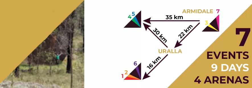
Armidale is going to host the next Australian Orienteering Championships at the end of September and beginning of October in 2024! Armidale is situated on The Granite Belt of the Great Dividing Range, and has played host to many regional and state orienteering events. This year it will offer a new area with captivating granite features and fast, runner-friendly terrain and foliage!

The whole festival will last from Saturday, 28th September to Sunday, 6th October and there is plenty of tourist and cultural activities to experience between races.

Australian Orienteering Championships

The races in the AOC include the Australian Sprint, Long, Middle, & Relay Championships and the Australian Schools Sprint, Long, & Relay Championships.

Also included in the program of races is the Thunderbolt Series which is made up of Sprint, Middle and Long Distance events over 3 days which is separate but complementary to the Australian Championship.

The Thunderbolt Series provides some extra racing while being a little less exacting – starting times are not scheduled, categories are not divided by age. The races do however offer differing levels of difficulty to suit wherever orienteers feel they’re at, with divisions from A (Hard course, most competitive) through G (Very Easy course, less hell-bent!). It’s a great event to race with family members in a less competitive environment while still enjoying the challenges of the course and the joys of the scenery.

Moira Whiteside Bequest    

Moira Whiteside Bequest recipient

This carnival is supported by a grant of $15,000 from the Moira Whiteside Bequest through Orienteering Australia. Orienteering is the beneficiary of a magnificent bequest by Moira Whiteside of Garingal Orienteers in NSW.

Read more

A fabulous introduction to orienteering in Sydney: the Centennial Park Permanent Course

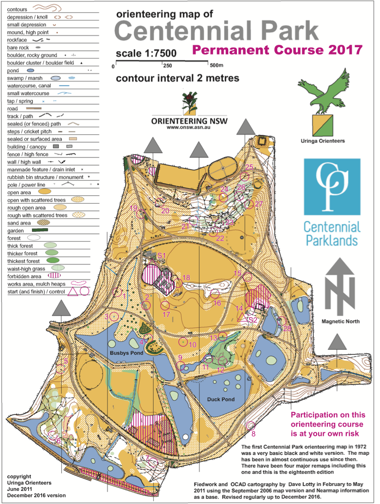
Did you know there’s a permanent orienteering course in the heart of Sydney’s Eastern Suburbs at Centennial Park? First mapped in 1972, it’s been revised 4 times over the year’s and is one of Australia’s finest permanent courses.

The course can serve as a fabulous introduction to orienteering, is easily reached from much of Sydney, and can be run at any time with just a map and compass if you wish. The course’s controls take the form of orange and white markers on posts with a number corresponding to the number of the control. Well-placed, they are not hidden but are not so obvious that you don’t have to do some serious navigating to find them.

The course itself is expansive, with lots of distance between controls to run and with nicely varied terrain – from forested slopes on the north side through fields in the centre to more low-lying ponds and swamps to the south. The wealth of distinctive landmarks makes navigation a lot easier for first-time orienteers.

One of the great things about this course is that, while it covers quite a lot of ground, it’s very hard/impossible to get lost on it, due to the easy geography, landmarks and roads. And hey, if you get tired, just drop in on one of the cafés for a cool drink to spritz yourself up again! A great introduction to orienteering in the centre of Sydney!

There are two possible Start+Finish markers located in the middle of the park, so if you’re coming by car, either park close to the northern café for S1 (Start/Finish 1) or on Dickens Drive or Loch Avenue for S2 (Start/Finish 2) and the course will lead you back to your car.

You will need a compass, running shoes and a map to complete the course. The map of the course was created by Uringa’s own Dave Lotty. You can download it out at the bottom of this page from the link just below and print it to take to Centennial Park.

Read more

New Permanent Orienteering Courses in Randwick!

Uringa has just helped Randwick City Council install two permanent orienteering courses at the Randwick Sustainability Hub.

 The Randwick Permanent Courses consist of an EASY course which is 1.4km and wheelchair accessible, and a MINI course which is suitable for younger children and is only 400m. They are a great introduction to orienteering for both able-bodied and kids with disabilities.

You don’t even need a compass to do these courses! You can download the map and control card straight to your phone here, or alternatively use the free MapRun app on your phone to navigate the courses!

Read more

PreO Means Orienteering For People With Disabilities!

There is a form of orienteering which has been created specifically to cater to those with disabilities – PreO! (short for Precision Orienteering)

PreO relies on placing controls in accessible situations by paths and roads (though often still deep in forests) to enable those with more limited mobility to enjoy orienteering. Competitors are given single control maps and descriptions at each timed control but the level of map-reading and decision making is significantly harder than comparable able-bodied orienteering, so decision-making is timed, not travelling speed between controls.

Competitors can take an escort with them to help with any accessibility issues (eg. pushing a wheelchair) but the escort must not help with any decision making. Extra helpers are also sometimes stationed on particularly steep slopes so accessibility doesn’t mean lack of adventure!

Primary ranking in each race is determined by how many controls the competitor gets right, with decision timing often a way of breaking a tie.

Click on the video above to see how PreO worked at O-Ringen 2022 in Uppsala, Sweden. You can read about PreO further at the British Orienteering website.

What a great way of making orienteering even more inclusive!

(BTW – We now have short, accessible orienteering courses at the Randwick Sustainability Hub in Sydney’s Eastern Suburbs.)

Read more

O-Ringen

O-Ringen 2022 Stage 1

O-Ringen is an iconic, 5-stage Swedish orienteering competition, held over a week every year in different regions of Sweden since 1965.

It usually attracts 15-20,000 competitors from around the world, from beginner to elite, toddlers to senior citizens.

It is a vastly well-organised event, but the O-Ringen organisers (like most every other orienteering organiser!) also incorporate a real sustainable ethos and policies in order to minimise the impact of the event.

It has a lovely, family-oriented, community-based vibe, with a full program of activities around the actual races.

In addition to the races and cultural events, there is also the O-Ringen Academy, where orienteers from around the world, local club leaders and everyday enthusiasts can all learn skills for furthering their own orienteering or their country’s orienteering programs.

Read more

25manna Relay

The 25manna is a relay orienteering race for club teams that has been held in Sweden every autumn since 1974. 

25 runners start in a team (hence the name), with the set of rules specifying the line-up of the teams. This creates the special appeal of the race, as amateurs and juniors can run together with elite runners in one team.

23 teams competed in the first race in 1974. Since then the number has steadily increased. 100 teams competed for the first time in 1982, 200 in 1985 and 300 in 1989. Since the early 1990s, the number of teams has been around 350.

Rules

  • at least seven women must be represented in the team
  • at least one member must be 16 years of age or younger
  • on certain legs of the race, runners must be under 14 or over 45 years old
Read more

Starting an Orienteering Course

Starting an orienteering race is simple but does consist of a few vital steps.

Warm-up

First you need to warmup as you would for any run – hip, knee and especially lower legs need to be primed and ready for the effort to maximise your performance and, most importantly, avoid injury.

Clear & Check

Then you walk to the start area where there are Clear and Check control points, which you use to clear the old data on your Sportident timing stick and check the stick is working correctly.

Choose Map

You then need to pick out the map of the race you’re doing.

On bigger races, there can be quite a range of maps to choose from so you have to make sure you’re picking the right one for your chosen race. Typically the maps are in shallow trays, labelled according to race, and helpers are around to make sure you get it right. This part obviously is key as on any race there will be easy, moderate and hard maps.

On many bigger races too, depending on the type, runners will be released in small groups at 30 second intervals to avoid crowding amongst the starters.

Start

Lastly, walk or run to the Start Control and insert your timing stick into the control to start your race proper. And you’re off!

Read more

Orienteering – How To Use The Compass

Make sure that the map and the compass flat and you turn the map around until the blue lines point north – the same direction as the red arrow on your compass will be pointing. This is called orientating the map.

Thumbing the map is another technique where you use a finger or thumb set against your route to measure your progress. For instance, on a fairly standard 1:10,000 scale map, 1cm on the map means 100 metres on the course, or about the width of a finger.

Folding the map is a common technique too where you fold up the map to just see the part of the course you’re on, making checking the map rapidly and often much easier as you run between controls.

Read more

Orienteering – How To Speed Up Through Checkpoints

Not stopping at controls/checkpoints is a key part of mastering faster orienteering. It’s about control-flow, or moving through the control smoothly, which is about the approach and planning the exit from the control.

For the approach, you use the symbols in your control description paper to work out the features close to the control and the control’s position relative to them. A control might be close to a boulder, but to the east side of it – and this would be shown in the control description. Of course, you will need to know the symbols denoting this information.

Planning the exit is about looking ahead of the control immediately ahead of you to the next and plotting a direction and something of the route in advance. This route planning and visualising in advance is one of the major challenges of orienteering.

Read more